
Home | Who are we? | Contact Us
![]()
![]()
![]()
![]()
![]()

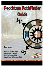
PathFinder Guide Book & Maps
The Peachtree PathFinder Map and Guide Book are comprehensive resources for the 100+ miles of recreational paths in Fayette County, Ga.
The full-color map opens to 22 x 33 inches. The Guide Book features 9 full-color, larger scale maps.
Although the first recreational paths appeared in 1979 in Peachtree City, navigating the system has been pretty much a mystery every since. Inadequate maps left people fending for themselves. While some like fact that every trip onto the paths could potentially be a very long adventure, others look at the prospect with fright.
The PathFinder maps and guides have been a welcome addition to the South Atlanta Region. The book is a 70+ page reference for all things relating to the recreational or golf cart paths. Both map and guide include 85+ miles of paths in Peachtree City, 10 miles of Tyrone paths, 5+ miles in Fayette County, and about 10 miles of walking paths.
The book is called the “low-tech laptop” for good reason. A coil binding makes it easy to open the book and set on one’s lap while driving a golf cart. The best feature is a series of fold out maps with enough detail to get even the map-challenged adventurer to the right destination.
The guide book maps have been printed using a 4th generation Xerox technology, which makes the maps quite durable.
In addition to the folded maps and guide book, a poster map also is available.
Peachtree PathFinder Guide
Book*
6 x 8 1/2 , sturdy laminated cover
Pull-out maps, coil binding
$20, $5 s/h
Peachtree PathFinder Map*
Full Color Map of Fayette County Recreational Paths
22 x 34, folds to 6 x 11, light plastic cover
$6.50, $3 s/h
Peachtree PathFinder Map
Poster*
22 x 34
$8 or $12 laminated, $5 s/h
*PathFinder Publications are available at several locations in Peachtree City, GA. Go to the www.ptpathfinder.com home page for a retailer list. The posters are only available from the publisher. All items may be picked up directly from the publisher’s office. Contact us at info@2bpress.com for more information.
770-487-1348 | FAX 770-487-9112 | #206 Clear Springs | Peachtree City,
GA 30269 |
info@2bpress.com